
More Information
view allVideos
Videos

The Winter of 2013 – 2014: A Cold, Snowy and Icy Winter in North America
This animation shows the snow cover over North America during the 2013-2014 winter as well as the ice concentration over the Great Lakes. The date and a graph showing the percent of ice cover over the Great Lakes and Lake Superior is shown on this version. file size is 5.2 MB
Snow Cover & Sea Ice Animation
This animation shows the advance and retreat of daily snow cover along with daily sea ice surface temperature globally from September 2002 through May 2003. file size is 31MB
Surface Temperature of the Greenland Ice Sheet During the Summer of 2005
This animation shows daily surface temperature of the Greenland ice sheet from May 1 through September 1, 2005. An overlay contains a date bar, a color bar and text labels. file size is 14MB
Daily Snow and Sea Ice Temperature over the North Pole
This animation shows the daily advance and retreat of snow cover, and sea ice surface temperature over the North Pole during the winter of 2002-2003. file size is 31MB
Daily Snow and Sea Ice Temperature over North America
This animation shows the daily advance and retreat of snow cover, and sea ice surface temperature over North America during the winter of 2002-2003. file size is 15MB
Daily Snow and Sea Ice Temperature over Europe
This animation shows the daily advance and retreat of snow cover, and sea ice surface temperature over Europe during the winter of 2002-2003. file size is 31MB
Daily Snow and Sea Ice Temperature over Asia
This animation shows the daily advance and retreat of snow cover, and sea ice surface temperature over Asia during the winter of 2002-2003. file size is 7MB


VNP10A1F snow product
The daily cloud-gap-filled (CGF) snow cover product, VMP10A1F, provides a 375-m resolution daily "cloud-free" map of snow cover extent. The VNP10A1F is in HDF-EOS5 format and includes variables and attributes that follow netCDF CF-1.6 conventions for local and global attributes and for geolocation which allow for more tools for users to work with the product.
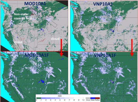
Examples of MODIS and VIIRS standard and cloud-gap-filled (CGF) snow maps on 14 April 2012 for parts of the western U.S./southwestern Canada. Top left panel: MODIS MOD10A1 C6.1 snow map showing extensive cloud cover on 14 April 2012. Top right panel: VIIRS VNP10A1 C1 snow map also showing extensive cloud cover on 14 April 2012. Bottom left panel: MOD10A1F C6.1 CGF map corresponding to the MOD10A1 snow map in the top left panel, for 14 April 2012. Bottom right panel: VNP10A1F CGF map corresponding to the VNP10A1 snow map in the top right panel, for 14 April 2012. In all of the snow maps, non-snow-covered land is shown in green (from Hall et al., 2019).
Further reading
Hall, D.K., G.A. Riggs, J.L. Foster and S. Kumar, 2010: Development and validation of a cloud-gap filled MODIS daily snow-cover product, Remote Sensing of Environment, 114:496-503, https://doi:10.1016/j.rse.2009.10.007.
Hall, D. K., G. A. Riggs, N.E. DiGirolamo and M.O. Román, 2019: MODIS Cloud-Gap Filled Snow-Cover Products: Advantages and Uncertainties, Hydrology and Earth System Sciences, 23:5227-5241, https://doi.org/10.5194/hess-23-5227-2019.
Hall, D.K., D.S. O'Leary III, N.E. DiGirolamo, and D.K. Kang, 2020: The Role of Declining Snow Cover in the Desiccation of the Great Salt Lake, Utah, Using MODIS Data, Remote Sensing of Environment, Terra@20 Special Issue, 252:112106. https://doi.org/10.1016/j.rse.2020.112106
Riggs, G.A., D.K. Hall and M.O. Román, 2017: Overview of NASA’s MODIS and Visible Infrared Imaging Radiometer Suite (VIIRS) snow-cover earth system data records, Earth Syst. Sci. Data, 9(2):765-777, https://www.earth-syst-sci-data-discuss.net/essd-2017-25/.
Riggs, G.A. and D.K. Hall, 2021: VIIRS Snow Products User Guide for C2, https://modis-snow-ice.gsfc.nasa.gov/?c=userguides
Riggs, G.A., D.K. Hall and M.O. Román, 2019: Continuity of MODIS and VIIRS snow cover extent data products for development of an Earth Science Data Record, Remote Sensing, 12:3781, https://nsidc.org/sites/nsidc.org/files/technical-references/Riggs&Hall.2020.pdf
