MOD10C2 / MYD10C2 snow products
The eight-day climate-modeling grid (CMG) snow-cover data product is generated by merging all the MOD10A2 (or MYD10A2) products (tiles) for an eight-day period and binning that 500 m data to 1/20°, or about 5.6 km resolution to create a global CMG map of snow cover. The size of the arrays is 3600 rows by 7200 columns. Snow cover, cloud cover and quality-assurance information are included in the product. See the validation webpage for details on the validation and validation definitions.
Since more than 99% of Antarctica is snow covered, the Antarctic continent is mapped as completely snow covered. During the summer up to 1% of the continent may be snow-free - mostly on the Antarctic Peninsula. That amount is less than the global error rate for snow mapping for the CMG snow products.
A land base map used in binning the MOD10A2 and MYD10A2 data was created from the University of Maryland 1 km global land cover mask. The base land extent map indicates the amount of land in a CMG cell and is used to determine if the cell is processed for snow and is used in the calculation of the confidence index. A land percentage of 12% in a CMG cell is used as the threshold to determine that a cell is considered as land.
Due to the operation of the MODIS instrument switching from day to night operation as the orbit passes a terminator, affected swaths of Level-2 data contain both visible data, and fill data. That combination is passed through the series of snow products to the CMG. In the CMG that combination is manifest as an apparent discontinuity of data progressing through a region of darkness. Typically what is seen is a sharp change from observations obtained in daylight to darkness, e.g. polar darkness. The region of darkness extends towards the pole but changes irregularly to values of no observations, i.e. values of 0. Then there is a sharp change to fill data because the top row of tiles in the sinusoidal grid is typically not generated when the polar region is in total darkness. The user should interpret all regions poleward of the first darkness data as being in darkness. Methods of removing that apparent data discontinuity in regions of darkness are being investigated.
For a full description of the MOD10C2 and MYD10C2 products, see the Snow Products User Guide and / or the ATBD.
View Images, Download Data
Below is an example of a beta-quality global climate-modeling grid (CMG) 8-day composite snow map at ~5.6-km resolution. Algorithm enhancements have not yet been applied to this image. Click on the thumbnail image to open a larger view of the image. To download the corresponding data for this image, click on the desired data format listed directly below the thumbnail. Flat binary data formats are provided. The flat binary snow and cloud files are 8 bit, 7200x3600 arrays. Data ranges are listed in the tables below.
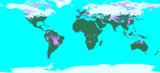
Download Full Size Image Image acquired: February 26 - March 5, 2011

