MOD10A1F / MYD10A1F snow products
MOD10A1F is a new daily 'cloud-gap-filled' (CGF) gridded snow cover product produced in Collection 6.1. The algorithms to produce both Terra and Aqua snow maps provide a 500-m resolution daily CGF map of snow cover extent. A CGF daily map is generated by retaining a previous day non-cloud observation when the current day has a cloud observation. The data product includes the CGF snow cover map, a cloud persistence map, the basic QA and flags for observations, and the NDSI snow cover map from the corresponding daily MOD10A1 product.
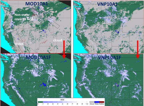
Examples of MODIS and VIIRS standard and cloud-gap-filled (CGF) snow maps on 14 April 2012 for parts of the western U.S./southwestern Canada. Top left panel: MODIS MOD10A1 C6.1 snow map showing extensive cloud cover on 14 April 2012. Top right panel: VIIRS VNP10A1 C1 snow map also showing extensive cloud cover on 14 April 2012. Bottom left panel: MOD10A1F C6.1 CGF map corresponding to the MOD10A1 snow map in the top left panel, for 14 April 2012. Bottom right panel: VNP10A1F CGF map corresponding to the VNP10A1 snow map in the top right panel, for 14 April 2012. In all of the snow maps, non-snow-covered land is shown in green (from Hall et al., 2019).
Further reading
Hall, D.K., G.A. Riggs, J.L. Foster and S. Kumar, 2010: Development and validation of a cloud-gap filled MODIS daily snow-cover product, Remote Sensing of Environment, 114:496-503, https://doi:10.1016/j.rse.2009.10.007.
Hall, D. K., G. A. Riggs, N.E. DiGirolamo and M.O. Román, 2019: MODIS Cloud-Gap Filled Snow-Cover Products: Advantages and Uncertainties, Hydrology and Earth System Sciences, 23:5227-5241, https://doi.org/10.5194/hess-23-5227-2019.
Hall, D.K., D.S. O'Leary III, N.E. DiGirolamo, and D.K. Kang, 2020: The Role of Declining Snow Cover in the Desiccation of the Great Salt Lake, Utah, Using MODIS Data, Remote Sensing of Environment, Terra@20 Special Issue, 252:112106. https://doi.org/10.1016/j.rse.2020.112106
Riggs, G.A., D.K. Hall and M.O. Román, 2017: Overview of NASA’s MODIS and Visible Infrared Imaging Radiometer Suite (VIIRS) snow-cover earth system data records, Earth Syst. Sci. Data, 9(2):765-777, https://www.earth-syst-sci-data-discuss.net/essd-2017-25/.
Riggs, G.A., D.K. Hall and M.O. Román, 2019: MODIS Snow Products User Guide for C6.1, https://modis-snow-ice.gsfc.nasa.gov/?c=userguides
Riggs, G.A., D.K. Hall and M.O. Román, 2019: Continuity of MODIS and VIIRS snow cover extent data products for development of an Earth Science Data Record, Remote Sensing, 12:3781, https://nsidc.org/sites/nsidc.org/files/technical-references/Riggs&Hall.2020.pdf

