
More Information
view allVideos
Videos

The Winter of 2013 – 2014: A Cold, Snowy and Icy Winter in North America
This animation shows the snow cover over North America during the 2013-2014 winter as well as the ice concentration over the Great Lakes. The date and a graph showing the percent of ice cover over the Great Lakes and Lake Superior is shown on this version. file size is 5.2 MB
Snow Cover & Sea Ice Animation
This animation shows the advance and retreat of daily snow cover along with daily sea ice surface temperature globally from September 2002 through May 2003. file size is 31MB
Surface Temperature of the Greenland Ice Sheet During the Summer of 2005
This animation shows daily surface temperature of the Greenland ice sheet from May 1 through September 1, 2005. An overlay contains a date bar, a color bar and text labels. file size is 14MB
Daily Snow and Sea Ice Temperature over the North Pole
This animation shows the daily advance and retreat of snow cover, and sea ice surface temperature over the North Pole during the winter of 2002-2003. file size is 31MB
Daily Snow and Sea Ice Temperature over North America
This animation shows the daily advance and retreat of snow cover, and sea ice surface temperature over North America during the winter of 2002-2003. file size is 15MB
Daily Snow and Sea Ice Temperature over Europe
This animation shows the daily advance and retreat of snow cover, and sea ice surface temperature over Europe during the winter of 2002-2003. file size is 31MB
Daily Snow and Sea Ice Temperature over Asia
This animation shows the daily advance and retreat of snow cover, and sea ice surface temperature over Asia during the winter of 2002-2003. file size is 7MB


MOD10A1 / MYD10A1 snow products
MOD10A1 and MYD10A1 are tiles of daily snow cover at 500 m spatial resolution. The daily observation selected from multiple observations in a MOD10A1 (or MYD10A1) cell is the observation acquired nearest nadir and having the greatest coverage of the grid cell.
The daily MOD10A1 and MYD10A1 snow products are tiles of data gridded in the sinusoidal projection. Tiles are approximately 1200 x 1200 km in area. A single scientific data set (SDS) of snow cover and a single SDS of QA data along with local and global attributes comprise the data product file. The daily level 3 snow product is the result of selecting an observation from the multiple observations mapped to a cell of the MOD10_L2G (or MYD10_L2G) product. See the validation webpage for details on the validation and validation definitions.
MODIS Aqua Image (top) and MYD10A1 snow map (bottom) acquired on December 23, 2011
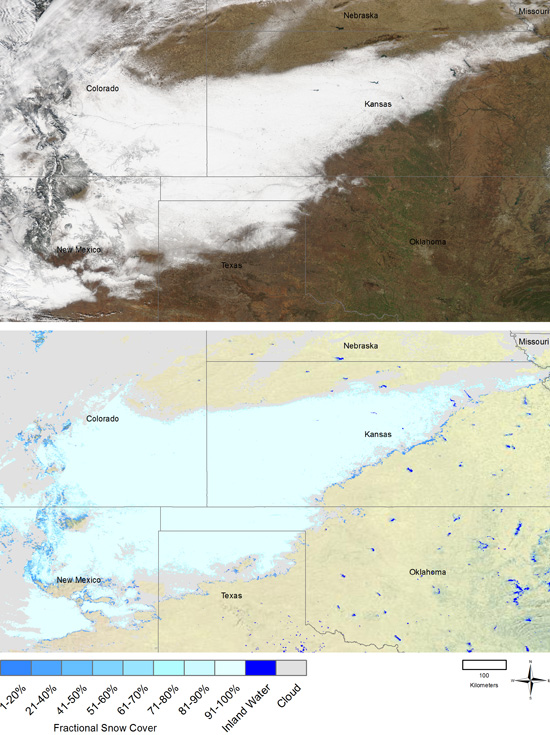
Please visit Earth Observatory for the full caption of the Aqua image (top).
An algorithm has been developed to map snow albedo using MODIS data. Daily snow albedo is a data layer in MOD10A1 or MYD10A1. In deriving albedo, atmospherically-corrected MODIS surface reflectances in individual MODIS bands for snow-covered pixels located in non-forested areas are adjusted for anisotropic scattering effects using a DIScrete Ordinates Radiative Transfer model (DISORT) and snow optical properties (Klein and Stroeve 2002). Currently in the algorithm, snow-covered forests are considered to be Lambertian reflectors. The adjusted spectral albedos are then combined into a broadband albedo measurement using a narrow-to-broadband conversion scheme developed specifically for snow by Shunlin Liang (written communication 2003) (Liang 2000; Klein and Hall 2000; Klein and Stroeve 2002). Thus derived, a near-global snow albedo product at 500-m resolution is available from February 2000 to the present as part of to the daily snow-cover product (MOD10A1).
The snow albedo product has been studied over the Greenland Ice Sheet and found to perform well (see Stroeve et al., 2005 and Hall et al., 2009). However it's performance is not as good in complex terrain (Sorman et al., 2006).For a full description of the MOD10A1 and MYD10A1 products, see the Snow Products User Guide.
References
- Hall, D. K., S. V. Nghiem, C. B. Schaaf, N. E. DiGirolamo, and G. Neumann, 2009: Evaluation of surface and near surface melt characteristics on the Greenland ice sheet using MODIS and QuikSCAT data, JGR, 114, F04006, doi:10.1029/2009JF001287.
- Klein, A.G. and J. Stroeve, 2002: Development and validation of a snow albedo algorithm for the MODIS instrument, Annals of Glaciology, 34:45-52.
- Shunlin Liang, written communication, 2003.
- Liang, S., 2000: Narrow to broadband conversion of land surface albedo I: algorithms, Remote Sensing of Environment, 76:213-238.
- Klein, A.G., D.K. Hall and A.W. Nolin, 2000: Development of a Prototype Snow Albedo Algorithm for the NASA MODIS Instrument, Proceedings of the 57th Eastern Snow Conference, 18-19 May 2000, Syracuse, NY, pp. 143-157.
- Stroeve, J., J. Box, and T. Haran, 2006: Evaluation of the MODIS (MOD10A) daily snow albedo product over the Greenland ice sheet, Remote Sensing of Environment, 105, 155– 171, doi:10/1016/j.rse.2006.06.009.
- Sorman, A. U., Z. Akyurek, A. Sensoy, A. A. Sorman, and A. E. Tekeli, 2007: Commentary on comparison of MODIS snow cover and albedo products with ground observations over the mountainous terrain of Turkey, Hydrol. Earth Syst. Sci., 11, 1353-1360.
