
More Information
view allVideos
Videos

The Winter of 2013 – 2014: A Cold, Snowy and Icy Winter in North America
This animation shows the snow cover over North America during the 2013-2014 winter as well as the ice concentration over the Great Lakes. The date and a graph showing the percent of ice cover over the Great Lakes and Lake Superior is shown on this version. file size is 5.2 MB
Snow Cover & Sea Ice Animation
This animation shows the advance and retreat of daily snow cover along with daily sea ice surface temperature globally from September 2002 through May 2003. file size is 31MB
Surface Temperature of the Greenland Ice Sheet During the Summer of 2005
This animation shows daily surface temperature of the Greenland ice sheet from May 1 through September 1, 2005. An overlay contains a date bar, a color bar and text labels. file size is 14MB
Daily Snow and Sea Ice Temperature over the North Pole
This animation shows the daily advance and retreat of snow cover, and sea ice surface temperature over the North Pole during the winter of 2002-2003. file size is 31MB
Daily Snow and Sea Ice Temperature over North America
This animation shows the daily advance and retreat of snow cover, and sea ice surface temperature over North America during the winter of 2002-2003. file size is 15MB
Daily Snow and Sea Ice Temperature over Europe
This animation shows the daily advance and retreat of snow cover, and sea ice surface temperature over Europe during the winter of 2002-2003. file size is 31MB
Daily Snow and Sea Ice Temperature over Asia
This animation shows the daily advance and retreat of snow cover, and sea ice surface temperature over Asia during the winter of 2002-2003. file size is 7MB


Sea Ice
 Sea ice off the east coast of Baffin Island, Canada.
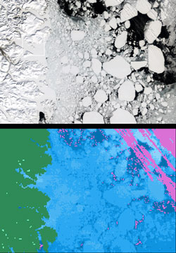
MODIS reflectance image (top) and MODIS sea ice product (bottom) from May 5, 2001.
Sea ice off the east coast of Baffin Island, Canada.
MODIS reflectance image (top) and MODIS sea ice product (bottom) from May 5, 2001.
Sea ice forms from the freezing of sea water. Sea ice covers roughly 7% of the Earth's oceans and may attain a thickness of 3 m or more. Movement of sea ice causes deformation of the ice pack. The presence of sea ice influences the temperature and circulation patterns of both the atmosphere and ocean. Sea ice reduces the amount of solar radiation absorbed at the ocean's surface, restricting exchanges of heat, mass, momentum and chemical constituents between the atmosphere and the ocean. With an ice cover, only 30-50% of the incident solar radiation is absorbed, the rest being reflected, while without the ice 85-95% is absorbed by the oceans (Washington and Parkinson, 1986).
The smooth and thin new sea ice is metamorphosed by temperature fluctuations, compressive and shear forces, surface currents and wind as it ages. In addition, as winter progresses, the ice thickens and snow falls on top of it. Ridge formation and surface roughness increases with age, and the angular edges and the smooth surfaces of first-year ice floes are transformed into rounded edges with hummocky-ridged surfaces that are characteristic of multi-year ice, or ice that has survived a summer's melt and is more than one year old.
Another important process that occurs as sea ice ages is desalinization. Sea water contains 30-35 parts per thousand salt. Brine drains out or is flushed out of the ice as the water freezes and the ice ages. If sea ice could be frozen extremely slowly, pure ice would result because of rejection of all salts during the freezing process. However, the freezing rate is normally too rapid to allow pure ice to form, so brine is trapped in the lattice structure of ice (Pounder, 1965). Both meltwater percolation and gravity expedite brine drainage. Typical sea ice salinities are 10-15 parts per thousand for newly-formed sea ice, 5-8 parts per thousand for 1-2 m thick first-year ice, or ice that is less than one year old, and 0.1-3.0 parts per thousand for mutiyear sea ice (Weeks, 1981).
Remote Sensing of Sea Ice
Satellite remote sensing is a useful tool for mapping sea ice concentration globally. A global year-round record of ice-covered Antarctic and Arctic seas was acquired from the Electrically Scanning Multichannel Microwave Radiometer (ESMR) on Nimbus-5 (Zwally et al., 1983). Global maps of sea ice extent and concentration have been produced. The ability of passive-microwave instruments to collect data through cloud cover and polar darkness makes them well suited for global monitoring of sea ice. However, microwave instruments do not collect data on albedo or temperature (Comiso, 2006; Hall et al., 2004) of sea ice. Which is important during the spring-summer-autumn seasons with respect to the energy exchange of sea ice. Measurement of sea ice albedo and temperature are possible with optical sensors such as the AVHRR, Landsat Thematic Mapper (TM) and Enhanced Thematic Mapper Plus (Lindsay and Rothrock, 1993; Key and Haefliger, 1992 and Key and Collins, 1997), ETM+, and MODIS (Riggs et al., 1999).
Daily sea ice extent and ice-surface temperature (IST) maps have been produced by MODIS since 2000 (Riggs et al., 1999; Hall et al., 2004) using the IST algorithm by Key and Haefliger (1992).
NSIDC has a website that summarizes the characteristics of over two dozen sea ice data sets. The site offers a complete summary and intercomparison of sea ice data. The sea ice site is available at: http://nsidc.org/data/seaice/index.html
References
Cavalieri, D., T. Markus, D.K. Hall, A. Ivanoff and E. Glick, 2010: "Assessment of Antarctic winter sea ice concentrations using Aqua MODIS,” TGARS, 48(9): 3331-3339.
Cavalieri, D., T. Markus, D. Hall, A. Gasiewski, M. Klein, and A. Ivanoff, 2006: "Assessment of EOS Aqua AMSR-E Arctic Sea Ice Concentrations Using Airborne Microwave and Landsat 7 Imagery,” IEEE Transactions on Geoscience and Remote Sensing, 3057-3069.
Comiso, J. C., 2006: Arctic warming signals from satellite observations, Weather, 61(3):70–76, doi:10.1256/wea.222.05.
Hall, D.K., J. Key, K.A. Casey, G.A. Riggs and D. J. Cavalieri, 2004: Sea ice surface temperature product from the Moderate-Resolution Imaging Spectroradiometer (MODIS), IEEE Transactions on Geoscience and Remote Sensing, 42(5):1076-1087.
Key, J.R. and Collins, J.B., 1997: "High-latitude surface temperature estimates from thermal satellite data," Remote Sensing of Environment, 61:302-309.
Key, J. and M. Haefliger, 1992: "Arctic ice surface temperature retrieval from AVHRR thermal channels," Journal of Geophysical Research, 97:(D5):5885-5893.
Lindsey, R. and D. Rothrock, 1993: "The calculation of surface temperature and albedo of Arctic sea ice from AVHRR," Annals of Glaciology, 17:174-183.
Pounder, E.R., 1965, Physics of Ice, Pergamon Press, Oxford, England, 151 p.
Washington, W.M. and C.L. Parkinson, 1986: An Introduction to Three-Dimensional Climate Modeling, University Science Books, Mill Valley, CA, 422 p.
Weeks, W., 1981: "Sea ice: the potential of remote sensing," Oceanus, 24:39-48.
Zwally, H.J., J.C. Comiso, C.L. Parkinson, W.J. Campbell, F.D. Carsey and P. Gloersen, 1983: "Antarctic Sea Ice, 1973-1976: Satellite Passive-Microwave Observations," NASA SP-459, 206 p. GPO., Washington, D.C.
