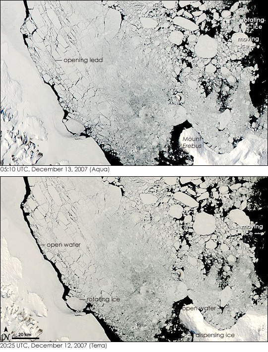
For those who live in the Northern Hemisphere, December is a time when days get steadily shorter and colder as winter settles in. In the south, however, December is the start of summer. Long sunlit days heat the frigid waters around Antarctica, releasing them from the coating of ice that developed during the winter. By mid-December, the seasonal ice in the Ross Sea had broken up and was quickly flowing away from the continent. The Moderate Resolution Imaging Spectroradiometer (MODIS) captured the movement in this pair of photo-like images of sea ice in the Ross Sea, taken on December 12 and December 13, 2007, within the span of nine hours. The ice was shifting, bunching and drifting northward so quickly that even in the short space of time that elapsed between the two images, noticeable differences developed.
The top image shows the Ross Sea as observed by the MODIS instrument flying on the Aqua satellite at 05:10 UTC on December 13. The MODIS instrument aboard the Terra satellite captured the lower image less than nine hours earlier, at 20:25 UTC on December 12. The images show that the ice was rapidly breaking up and drifting away from Antarctica. The bulk of the ice was rotating counterclockwise, moving generally northward. This movement is particularly evident in the upper right corner of the images. Chunks of ice that had been pointing to the upper right on December 12 (lower image) are nearly vertical a few hours later (top). Some of the ice visible in the lower image had drifted north beyond the top edge of the image, and pieces of ice along the edge of the pack moved several kilometers within the image. Ice that had been clustered south of Mount Erebus in the Terra image had drifted away by the time Aqua captured the top image.
The movement is also evident in the shifting patterns of open water. In many places, water that had been open when Terra MODIS captured the lower image were filled with ice by the time Aqua flew over hours later as the ice bunched and moved north. One such area of open water is right of Mount Erebus near the lower right corner of the images.
Another rapidly filled gap is along the shoreline on the left edge of the image. The gap along the shore, called a latent heat polynya caused by winds blowing off the continent, seemed to be narrowing for two reasons. First, the counterclockwise rotation of the entire ice pack was pushing some of the ice towards the shore. Second, the ice in the pack was breaking apart. Leads (long, narrow channels of open water) open between chunks of ice as the ice spreads apart. The opening of the leads makes the dark lines separating the breaking ice more distinct. As the leads widen and the ice spreads, some of the ice gets pushed into the shore.
The broader view provided by the large images provides additional evidence that the ice is moving quickly. The size and shape of near-shore polynyas shifted along the entire coastline. Along the top of the large images, a broad area of open water filled with ice between the Terra and Aqua overpasses. The edge of the pack also moved several kilometers north between the two images. The large images provided above are at MODIS' maximum resolution of 250 meters per pixel. Both the Terra and the Aqua images are available in additional resolutions from the MODIS Rapid Response System.
Text and image courtesy of NASA's Earth Observatory.