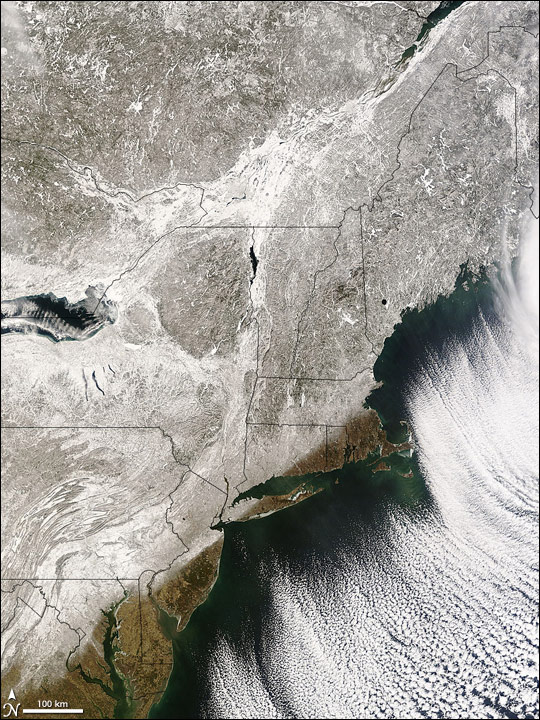
On February 14-15, 2007, a severe winter storm pummeled the northeastern United States and southeastern Canada. By the time the storm had blown out to sea, it had caused 15 deaths, according to CNN. On February 19, skies overhead cleared enough to allow the Moderate Resolution Imaging Spectroradiometer (MODIS) on NASA's Terra satellite to capture this view of the snowy landscape.
This image snows extensive snow cover along the east coast of the United States and stretching up into Quebec and Ontario. White snow and ice alternate with the gray-brown winter landscape, with white predominating, especially in Canada and around Lake Ontario. The snow followed a distinct path, leaving some states only partially buried in snow and ice. A snow-free swath lines the coast from boot-shaped Massachusetts south to Virginia. A rim of ice lines many beaches and inlets. To the east of the coast are cloud streets sculpted by winds that drove icy air from the North into a layer of moist air above the open waters of the Atlantic Ocean.
As reported by CNN, the snowstorm dropped more than 30 centimeters (1 foot) of snow in many places, and even left 106 centimeters (42 inches) in the southern Adirondacks in New York. On the heels of the snow came several inches of ice in some places. The storm trapped hundreds of motorists in their cars and left tens of thousands without power in the Midwest, the Mid-Atlantic, and Northeast.
Text and image courtesy of NASA's Earth Observatory.