
view2000-14 Greenland Ice-Surface Temp (IST)
MODIS Snow and Ice Data Products
| Data Product Name | ESDT* | Res. | Avail |
| Swath snow-cover | MOD10_L2 MYD10_L2 |
500 m | NSIDC | |
| Daily tile snow-cover | MOD10A1 MYD10A1 |
500 m | NSIDC | |
| 8-day composite snow-cover | MOD10A2 MYD10A2 |
500 m | NSIDC | |
| Daily snow-cover CMG‾ | MOD10C1 MYD10C1 |
0.05° (or ~5.6km) | NSIDC | |
| Daily snow-cover CMG‾ |
N / A | 0.25° | ||
| 8-day composite snow-cover CMG‾ |
MOD10C2 MYD10C2 |
0.05° | NSIDC | |
| Monthly snow-cover CMG‾ | MOD10CM MYD10CM |
0.05° | NSIDC | |
| Swath sea ice extent and IST** | MOD29 MYD29 |
1 km | NSIDC | |
| Daily sea ice extent and IST**, daytime | MOD29P1D MYD29P1D |
1 km | NSIDC | |
| Daily sea ice extent and IST**, nighttime | MOD29P1N MYD29P1N |
1 km | NSIDC | |
| Daily sea ice extent and IST CMG**,‾ |
MOD29E1D MYD29E1D |
0.05° | NSIDC |
More Information


view allVideos
Videos

The Winter of 2013 – 2014: A Cold, Snowy and Icy Winter in North America
This animation shows the snow cover over North America during the 2013-2014 winter as well as the ice concentration over the Great Lakes. The date and a graph showing the percent of ice cover over the Great Lakes and Lake Superior is shown on this version. file size is 5.2 MB
Snow Cover & Sea Ice Animation
This animation shows the advance and retreat of daily snow cover along with daily sea ice surface temperature globally from September 2002 through May 2003. file size is 31MB
Surface Temperature of the Greenland Ice Sheet During the Summer of 2005
This animation shows daily surface temperature of the Greenland ice sheet from May 1 through September 1, 2005. An overlay contains a date bar, a color bar and text labels. file size is 14MB
Daily Snow and Sea Ice Temperature over the North Pole
This animation shows the daily advance and retreat of snow cover, and sea ice surface temperature over the North Pole during the winter of 2002-2003. file size is 31MB
Daily Snow and Sea Ice Temperature over North America
This animation shows the daily advance and retreat of snow cover, and sea ice surface temperature over North America during the winter of 2002-2003. file size is 15MB
Daily Snow and Sea Ice Temperature over Europe
This animation shows the daily advance and retreat of snow cover, and sea ice surface temperature over Europe during the winter of 2002-2003. file size is 31MB
Daily Snow and Sea Ice Temperature over Asia
This animation shows the daily advance and retreat of snow cover, and sea ice surface temperature over Asia during the winter of 2002-2003. file size is 7MBProject Description
Moderate Resolution Imaging Spectroradiometer (MODIS) and NASA Visible Infrared Imaging Radiometer Suite (VIIRS) snow-cover products are snow-covered area maps that provide swath-based and daily maps of the Earth's land areas. Both MODIS and VIIRS sea ice products are also available for the areas of the Earth's oceans that are subject to ice cover, providing ice-surface temperature (IST) from MODIS and VIIRS, and sea ice concentration (from VIIRS).
The MODIS is a 36-channel visible to thermal-infrared sensor that was first launched as part of the Earth Observing System (EOS) Terra payload on 18 December 1999, with spatial resolutions varying from 250 m to 1 km. A second, nearly identical MODIS sensor, was launched as part of the payload on the Aqua satellite on 4 May 2002.
The Suomi-National Polar-orbiting Partnership (S-NPP) satellite was launched on 28 October 2011 with the 22-channel VIIRS on board. Five of the VIIRS channels are high-resolution image bands or I-bands (375 m), and sixteen are moderate-resolution bands or M-bands (775 m). VIIRS also hosts a panchromatic Day/Night band (DNB). SNPP serves as a bridge between the Earth Observing System (EOS) satellites, including the Terra and Aqua, and the next-generation NASA-NOAA Joint Polar Satellite System (JPSS).
Data products developed from the MODIS and VIIRS sensors are designed to measure land, ocean and atmosphere parameters to improve our understanding of key Earth processes and global climate change.
The MODIS and VIIRS snow and ice products are archived at the National Snow and Ice Data Center (NSIDC) in Boulder, CO.
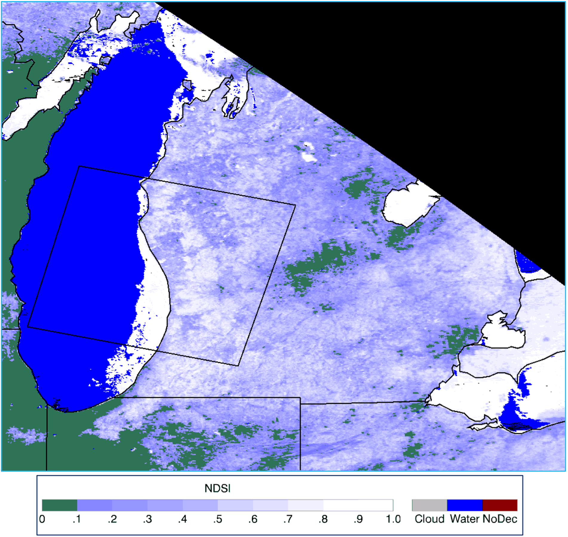
Aqua MODIS Normalized Difference Snow Index (NDSI) map of Lake Michigan and snow cover in part of the state of Michigan acquired on 11 March 2015.
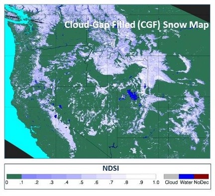
Terra MODIS cloud-gap-filled (CGF) MOD10A1F NDSI snow map of the western United States acquired on 19 March 2012.
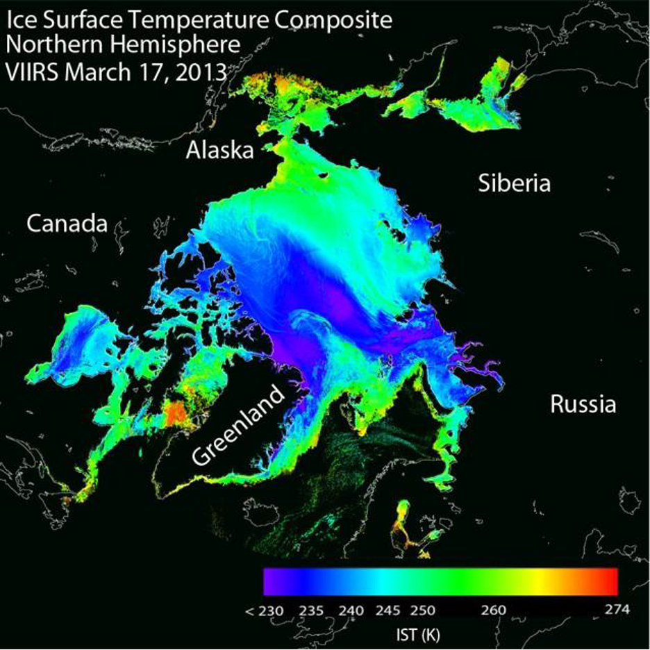
Interface Data Processing System (IDPS) VIIRS IST map -- Northern Hemisphere, March 17, 2013. Cloud mask has not been applied. By D. Baldwin, U. of Colorado, Boulder. From S-NPP VIIRS Ice Surface Temperature Algorithm Theoretical Basis Document.
