
More Information
view allVideos
Videos

The Winter of 2013 – 2014: A Cold, Snowy and Icy Winter in North America
This animation shows the snow cover over North America during the 2013-2014 winter as well as the ice concentration over the Great Lakes. The date and a graph showing the percent of ice cover over the Great Lakes and Lake Superior is shown on this version. file size is 5.2 MB
Snow Cover & Sea Ice Animation
This animation shows the advance and retreat of daily snow cover along with daily sea ice surface temperature globally from September 2002 through May 2003. file size is 31MB
Surface Temperature of the Greenland Ice Sheet During the Summer of 2005
This animation shows daily surface temperature of the Greenland ice sheet from May 1 through September 1, 2005. An overlay contains a date bar, a color bar and text labels. file size is 14MB
Daily Snow and Sea Ice Temperature over the North Pole
This animation shows the daily advance and retreat of snow cover, and sea ice surface temperature over the North Pole during the winter of 2002-2003. file size is 31MB
Daily Snow and Sea Ice Temperature over North America
This animation shows the daily advance and retreat of snow cover, and sea ice surface temperature over North America during the winter of 2002-2003. file size is 15MB
Daily Snow and Sea Ice Temperature over Europe
This animation shows the daily advance and retreat of snow cover, and sea ice surface temperature over Europe during the winter of 2002-2003. file size is 31MB
Daily Snow and Sea Ice Temperature over Asia
This animation shows the daily advance and retreat of snow cover, and sea ice surface temperature over Asia during the winter of 2002-2003. file size is 7MB


MOD10_L2 / MYD10_L2 snow products
These products are generated using the MODIS calibrated radiance data products (MOD02HKM and MYD02HKM), the geolocation products (MOD03 and MYD03), and the cloud mask products (MOD35_L2 and MYD35_L2) as inputs. The MODIS snow algorithm output (MOD10_L2 and MYD10_L2) contains scientific data sets (SDS) of snow cover, quality assurance (QA) SDSs, latitude and longitude SDSs, local attributes and global attributes. The snow cover algorithm identifies snow-covered land; it also identifies snow-covered ice on inland water. For complete global coverage a MOD10_L2 (or MYD10_L2) snow product would be generated for all swaths (approximately 288 swaths) of Terra or Aqua orbits acquired in daylight on the Earth. See the validation webpage for details on the validation and validation definitions.
Example Images and Data
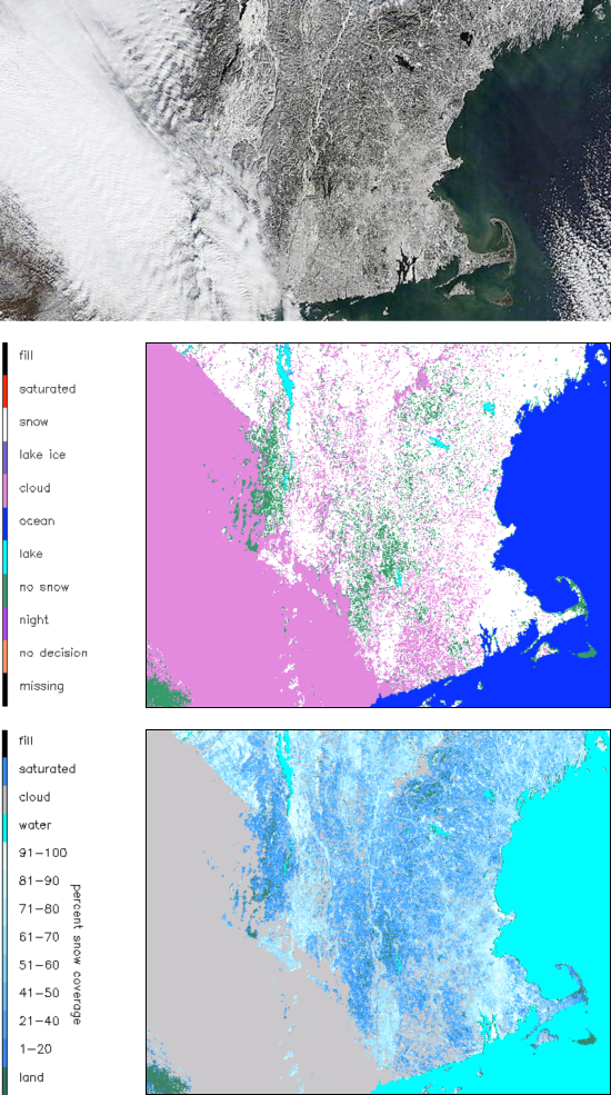 Images acquired on 28 December 2010 showing the result of a major snowstorm in the Northeastern United States. The image on top is the true-color image from the MOD09 reflectance product; the center image is a binary snow map; and the image on the bottom represents fractional snow cover from Collection 5, so that various shades of blue indicate different fractions of snow cover with in each pixel.
For a full description of the MOD10_L2 and MYD10_L2 products, see the Snow Products User Guide and / or the ATBD.
