
More Information
view allVideos
Videos

The Winter of 2013 – 2014: A Cold, Snowy and Icy Winter in North America
This animation shows the snow cover over North America during the 2013-2014 winter as well as the ice concentration over the Great Lakes. The date and a graph showing the percent of ice cover over the Great Lakes and Lake Superior is shown on this version. file size is 5.2 MB
Snow Cover & Sea Ice Animation
This animation shows the advance and retreat of daily snow cover along with daily sea ice surface temperature globally from September 2002 through May 2003. file size is 31MB
Surface Temperature of the Greenland Ice Sheet During the Summer of 2005
This animation shows daily surface temperature of the Greenland ice sheet from May 1 through September 1, 2005. An overlay contains a date bar, a color bar and text labels. file size is 14MB
Daily Snow and Sea Ice Temperature over the North Pole
This animation shows the daily advance and retreat of snow cover, and sea ice surface temperature over the North Pole during the winter of 2002-2003. file size is 31MB
Daily Snow and Sea Ice Temperature over North America
This animation shows the daily advance and retreat of snow cover, and sea ice surface temperature over North America during the winter of 2002-2003. file size is 15MB
Daily Snow and Sea Ice Temperature over Europe
This animation shows the daily advance and retreat of snow cover, and sea ice surface temperature over Europe during the winter of 2002-2003. file size is 31MB
Daily Snow and Sea Ice Temperature over Asia
This animation shows the daily advance and retreat of snow cover, and sea ice surface temperature over Asia during the winter of 2002-2003. file size is 7MB


MOD10A2 / MYD10A2 snow products
The MOD10A2 and MYD10A2 products are composites of eight days of snow maps in the sinusoidal grid.
An eight-day compositing period was chosen because that is the exact ground track repeat period of the Terra and Aqua platforms. Snow cover over eight days is mapped as maximum snow extent in one SDS and as a chronology of observations in the other SDS. Eight-day periods begin on the first day of the year and extend into the next year. The product can be produced with two to eight days of input. There may not always be eight days of input, because of various reasons, so the user should check the attributes to determine on what days observations were obtained. See the validation webpage for details on the validation and validation definitions.
Example Images and Data
Click on the thumbnail image to open a larger view of the image. To download the corresponding data for this image, click on the HDF data file listed directly below the thumbnail.
April 23, 2002
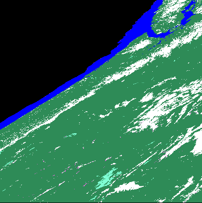 Northwest US MOD10A2.2002113.hdf.gz |
Image Color Legend:snow snow/cloud free land cloud open ocean/cloud free water no data/night |
For a full description of the MOD10A2 and MYD10A2 products, see the Snow Products User Guide and / or the ATBD.
